
By Zhetao Zhang, Hao Wang, and Yuanxi Yang
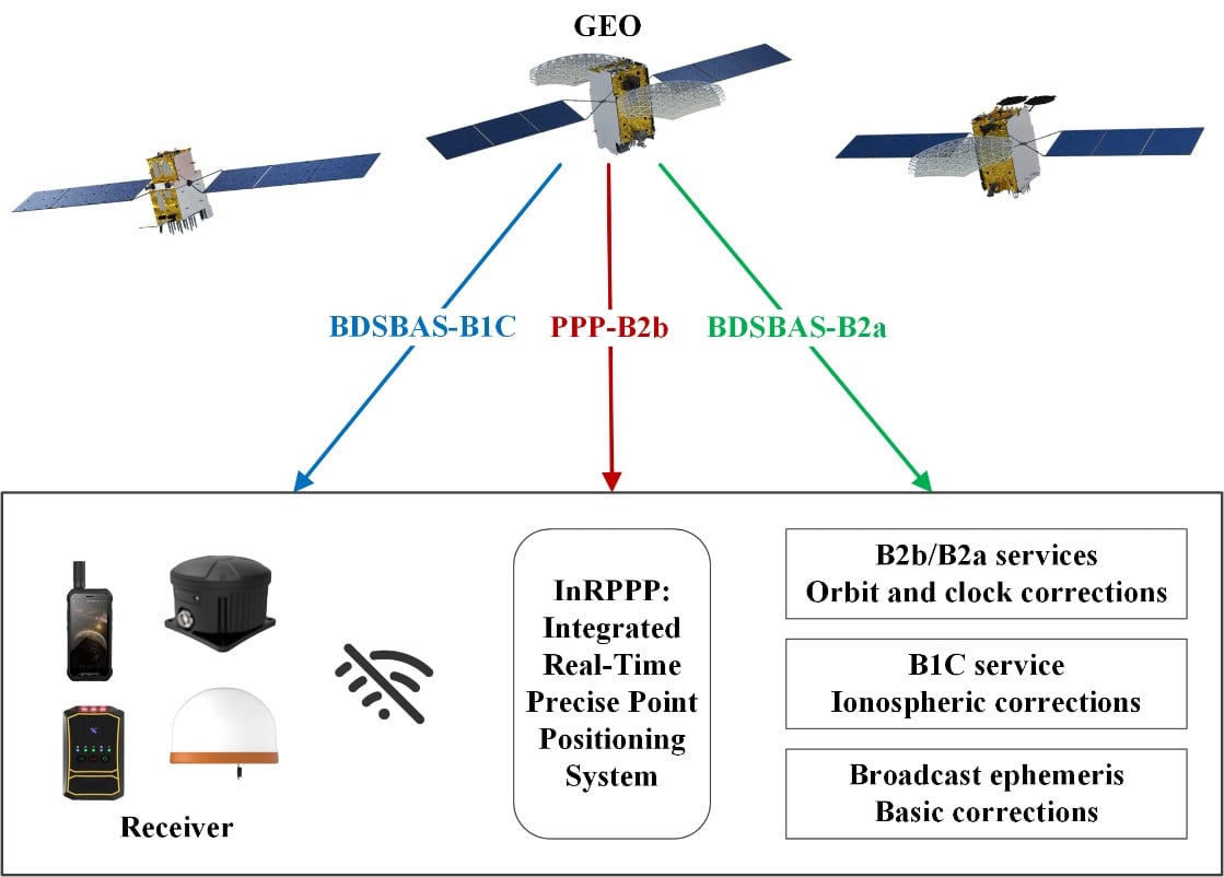
The development of an Integrated Real-Time Precise Point Positioning (InRPPP) system leveraging BeiDou Navigation Satellite System (BDS) B2b, B2a, and B1C services has significantly enhanced satellite-based positioning accuracy. By resiliently utilizing these augmentation messages, the InRPPP system corrects satellite orbit and clock errors and mitigates ionospheric delays, outperforming traditional methods.
Experimental results from both static and kinematic conditions demonstrate superior performance, showing improved positioning accuracy, faster convergence times, and greater stability in challenging environments. This breakthrough offers potential for applications in real-time navigation, precision positioning, and disaster monitoring, with a broader impact on industries requiring reliable and continuous positioning data.
### Addressing Limitations of Traditional Satellite Positioning
Satellite-based navigation systems, like Real-Time Precise Point Positioning (RTPPP), are crucial for many industries that require accurate location data. However, these systems face limitations in areas with weak Internet connectivity or signal interference. BeiDou’s satellite augmentation services — namely B2b, B2a, and B1C — have emerged as a promising solution.
Yet, integrating these services into one cohesive system for optimal performance remained unexplored until now. This study pioneers the Integrated InRPPP system, which combines all three services to correct satellite clock and orbit errors as well as ionospheric delays, unlocking new levels of positioning accuracy.
### Innovative Integration: Combining B2b, B2a, and B1C Services
In a 2025 publication in *Satellite Navigation* (DOI: 10.1186/s43020-025-00172-x), researchers from the State Key Laboratory of Geo-Information Engineering, Key Laboratory of Surveying and Mapping Science and Geospatial Information Technology of MNR, State Key Laboratory of Spatial Datum, and Hohai University introduced the InRPPP system.
By leveraging B2b, B2a, and B1C services of the BeiDou system, the InRPPP approach corrects satellite orbit and clock errors while mitigating ionospheric delays. This integration enhances positioning accuracy, stability, and convergence times, offering more reliable and continuous real-time positioning—especially in environments where traditional systems struggle.
### Experimental Results: Significant Improvements in Accuracy and Stability
Static experiments showed the InRPPP system surpasses other methods with a 59.6% improvement in positioning accuracy and a 65.9% reduction in convergence time compared to using B2b, B2a, or B1C services individually.
In dynamic conditions, the system demonstrated enhanced stability and reduced signal interruptions, achieving up to a 34.3% improvement in accuracy.
The integration of these services also increases the number of visible satellites, enhancing Position Dilution of Precision (PDOP) values and ensuring better satellite geometry. This boosts both accuracy and continuity, making the system highly reliable even in high-occlusion or remote environments.
### Potential Applications and Industry Impact
The InRPPP system is a game-changer for fields such as geodesy, navigation, and disaster monitoring. Academician Yuanxi Yang from the Chinese Academy of Sciences, lead researcher behind the system, remarked:
> “The ability to integrate multiple BeiDou augmentation services into a single real-time positioning system represents a major breakthrough. By leveraging B2b, B2a, and B1C, our system offers a more reliable and accurate solution than anything available today.”
In both static and kinematic tests, the InRPPP system outperformed traditional positioning methods, demonstrating robustness and resilience in environments where signal conditions are less than ideal.
This system is already being applied in practical scenarios and has the potential to reshape industries reliant on satellite navigation and precise positioning.
### Broad Implications for Future Technologies
The InRPPP system’s implications are vast, with applications spanning autonomous vehicles, precision agriculture, disaster management, and geospatial services. Enhanced accuracy and stability can support real-time decision-making in critical environments.
Moreover, it promises to improve navigation resilience in regions with poor satellite visibility or signal interference. As technology advances, the InRPPP system could pave the way for even more robust solutions, contributing toward global sustainability goals and improving disaster response capabilities by providing uninterrupted and reliable positioning data.
—
*For further information and detailed study results, refer to the original publication in Satellite Navigation (DOI: 10.1186/s43020-025-00172-x).*
https://www.gpsworld.com/study-unlocking-superior-accuracy-with-advanced-bds-services/